
Meteorologists warn that Yasi will be the biggest cyclone any Queenslanders living today have seen
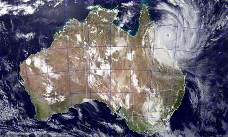 Yasi is a 500km-wide, category 5 tropical cyclone moving in a west-southwesterly direction off the north-east coast of Australia. Meteorologists expect it will make landfall near Innisfail in North Queensland at close to midnight local time.
Tropical cyclones (also known as hurricanes or typhoons in other parts of the world) start off as low-pressure weather systems that form over warm water and have sustained winds more than 63kph near their centre. These gale-force winds can reach out to hundreds of kilometres from the centre of the cyclone and, if the winds get to more than 118kph at the centre, they are upgraded to "severe". The storm gets its energy from oceans where the surface temperature is more than 26.5C.
Jonathan Nott of the Australasian Palaeohazards Research Unit at James Cook University said Yasi looked like it would be the most intense and largest cyclone in the area since 1918. "In that year we had two very intense systems cross the Queensland coast, one through Innisfail and one through Mackay. We haven't had anything comparable since then until Yasi. It's a serious event. It's the biggest one that anyone living today has seen in Queensland."
He said a major problem was Yasi's large diameter. "We commonly get 'midgets' in Queensland – small diameter but still intense tropical cyclones. From time to time we get one of these very, very large ones but the midgets have been more common in recent years. It makes it more unusual for us again to see a large diameter system here," he said. "It's going to cause storm tides to go through people's houses. We can expect some areas to be really badly impacted by the storm tide. Larry didn't come through at high tide; it came through on a lower tide. It wasn't as intense as this system and it wasn't as large either. It didn't get any storm tide into houses but this one most certainly will. I think it will show people just how dangerous it is to live so low relative to sea level and so close to the beach."
Nick Harvey, executive dean of the Faculty of Humanities and Social Sciences at Adelaide University and an expert on coastal processes said: "The storm surge can also be amplified by the funnelling effect of the coastline depending on its configuration. Notable storm surges in north Queensland have occurred in 1899 at Bathurst Bay, with dubious reports of a 12.2 m surge when many lives were lost from a pearling fleet, and Cyclone Althea in 1971 which produced a 3.6 m surge north of Townsville. There is concern that the storm surge with Tropical Cyclone Yasi could arrive at the same time as the high tide either this evening or tomorrow morning when the tide will be over 3m in Townsville."
At the centre of cyclone is the eye, a relatively area stretching up to 100km in diameter surrounded by a dense ring of cloud around 16 km high - this "eye wall" marks the area with the strongest winds and heaviest rainfall.
Mark Bradford, research director at the Centre for Infrastructure, Engineering and Safety at the University of New South Wales said that, if winds reached the predicted 300 kph, there would be considerable damage to towns. "Buildings built prior to 2002 were required to withstand up to 250 kph for this Cyclone Region C area of Australia. These were determined from historical data, and it was noted in drafting the new 2002 wind code that the incidence of Category 5 cyclones has increased in recent years. For many, if not all residential and industrial buildings, the wind loading is the critical load that the structure will experience and these structures would be very vulnerable. Severe storm surges are also predicted, with the water having at least the potential for destruction as experienced in Queensland a couple of weeks ago."
Nott said that Queenslanders had been lulled into a false sense of security because of the quiet cyclone activity since the 1970s. "We haven't planned properly, put it that way. It's going to shake people up and I hope get the planners and decisions makers to revise their approach to planning for this sort of thing."
Yasi is a 500km-wide, category 5 tropical cyclone moving in a west-southwesterly direction off the north-east coast of Australia. Meteorologists expect it will make landfall near Innisfail in North Queensland at close to midnight local time.Tropical cyclones (also known as hurricanes or typhoons in other parts of the world) start off as low-pressure weather systems that form over warm water and have sustained winds more than 63kph near their centre. These gale-force winds can reach out to hundreds of kilometres from the centre of the cyclone and, if the winds get to more than 118kph at the centre, they are upgraded to "severe". The storm gets its energy from oceans where the surface temperature is more than 26.5C.
Jonathan Nott of the Australasian Palaeohazards Research Unit at James Cook University said Yasi looked like it would be the most intense and largest cyclone in the area since 1918. "In that year we had two very intense systems cross the Queensland coast, one through Innisfail and one through Mackay. We haven't had anything comparable since then until Yasi. It's a serious event. It's the biggest one that anyone living today has seen in Queensland."
He said a major problem was Yasi's large diameter. "We commonly get 'midgets' in Queensland – small diameter but still intense tropical cyclones. From time to time we get one of these very, very large ones but the midgets have been more common in recent years. It makes it more unusual for us again to see a large diameter system here," he said. "It's going to cause storm tides to go through people's houses. We can expect some areas to be really badly impacted by the storm tide. Larry didn't come through at high tide; it came through on a lower tide. It wasn't as intense as this system and it wasn't as large either. It didn't get any storm tide into houses but this one most certainly will. I think it will show people just how dangerous it is to live so low relative to sea level and so close to the beach."
Nick Harvey, executive dean of the Faculty of Humanities and Social Sciences at Adelaide University and an expert on coastal processes said: "The storm surge can also be amplified by the funnelling effect of the coastline depending on its configuration. Notable storm surges in north Queensland have occurred in 1899 at Bathurst Bay, with dubious reports of a 12.2 m surge when many lives were lost from a pearling fleet, and Cyclone Althea in 1971 which produced a 3.6 m surge north of Townsville. There is concern that the storm surge with Tropical Cyclone Yasi could arrive at the same time as the high tide either this evening or tomorrow morning when the tide will be over 3m in Townsville."
At the centre of cyclone is the eye, a relatively area stretching up to 100km in diameter surrounded by a dense ring of cloud around 16 km high - this "eye wall" marks the area with the strongest winds and heaviest rainfall.
Mark Bradford, research director at the Centre for Infrastructure, Engineering and Safety at the University of New South Wales said that, if winds reached the predicted 300 kph, there would be considerable damage to towns. "Buildings built prior to 2002 were required to withstand up to 250 kph for this Cyclone Region C area of Australia. These were determined from historical data, and it was noted in drafting the new 2002 wind code that the incidence of Category 5 cyclones has increased in recent years. For many, if not all residential and industrial buildings, the wind loading is the critical load that the structure will experience and these structures would be very vulnerable. Severe storm surges are also predicted, with the water having at least the potential for destruction as experienced in Queensland a couple of weeks ago."
Nott said that Queenslanders had been lulled into a false sense of security because of the quiet cyclone activity since the 1970s. "We haven't planned properly, put it that way. It's going to shake people up and I hope get the planners and decisions makers to revise their approach to planning for this sort of thing."


