
") India has withdrawn the tsunami warning it issued after the first massive earthquake hit waters off Indonesia, which triggered off at least two more powerful aftershocks.
India has withdrawn the tsunami warning it issued after the first massive earthquake hit waters off Indonesia, which triggered off at least two more powerful aftershocks. 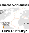 Parts of Indonesia's Sumatra island still remain in danger from a tsunami following the series of powerful earthquakes off the Indonesian coast on Wednesday, but damage across the Indian Ocean basin is not expected, an official with the US Pacific Tsunami Warning Center said.
 ''So far all we've seen is on the order of about a metre or three feet or so, peak-to-peak,'' said Barry Hirshorn, a geophysicist at center, referring to waves measured by gauges mounted on buoys.
''And we've observed that on our closest gauge to the actual epicenter. The gauge is just off northern shore of Sumatra,'' Hirshorn said. ''We don't expect damage basin-wide, but there is danger nearby the source. So the tsunami danger is to the coastlines closest to the earthquake, which would be northern Sumatra.
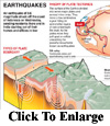
At least two major quakes with a magnitude exceeding 8.0 hit off the coast of Indonesia's Aceh province on Wednesday, the US Geological Survery said, and a tsunami warning remained in effect.
 The first quake measured 8.6 at a depth of 14.2 miles, according to the United States Geological Survey. The second quake was measured at 8.2 at a depth of 10.2 miles.
 Indonesia issued a fresh tsunami warning after the first aftershock with a preliminary magnitude of 8.2 shook its western coast.
The first 8.6-magnitude quake off Aceh province, hours earlier, spawned a wave around 30 inches (80 centimetres) high but caused no serious damage.
The US Geological Survey said the strong temblor that followed was centered 10 miles (16 kilometres) beneath the ocean around 380 miles (615 kilometres) from the provincial capital, Banda Aceh.
Harjadi, a local official who goes by only one name, said the new tsunami warning was for residents living along the western coast of the country.
It included Sumatra island and the Mentawai islands.


